A New York Times story, that can be found here, says that Venezuelan President Hugo Chavez is looking to take over the Caracas Country Club, one of the last bastions of elitist wealth, to create housing for people displaced by recent heavy rains.
"A state newspaper published a study this month saying that if the government expropriated the land of the Caracas Country Club and that of another club in the city, housing for 4,000 poor families could be built on the parcels," reads the Times article.
The course is one of the last designs of Charles Banks. According to George Bahto's biography of Charles Blair Macdonald, The Evangelist of Golf , the layout was constructed from 1928 to 1930. Banks died in 1931.
According to the Times story, the grounds of Caracass CC designed by the Olmsted Brothers, who are best known for creating parks, public and private, as well as college campuses.
The demise of Caracas CC appears inevitable.
"We are waiting,” Manuel Fuentes, 69, the country club’s vice president, said to the Times in the English he learned as a teenager while studying at the New York Military Academy. “It would be a tragedy for the city to lose such an icon, but it’s a scenario we’ve been forced to acknowledge."
Caracas CC hosted the OMEGA Mission Hills World Cup Latin American qualifier in 2009. The Venezuelan team of Jhonattan Vegas and Alfredo Adrian qualified and went on to place 12th out of 28 teams in the World Cup played in China that year.
Tuesday, December 28, 2010
Wednesday, December 22, 2010
Donald Ross at Cohasset (Mass.) Golf Club
This past summer, I was retained by Cohasset Golf Club to write a brief history of the golf course for its website, as sort of a way to help members appreciate what they have in their Donald Ross-designed layout, and to educate prospective members about the current course that opened in 1920 and was renovated by Ron Prichard in 2000. In 2009-2010 the club undertook indepth water remediation project with Agri-Scape Golf Course Construction doing the work that affected three holes.
The Donald Ross Society has posted the piece on their website and you can read it here in its entirety.
Cohasset has quite a history, some of which remains to be rediscovered. Considered a summer club for wealthy Bostonians, the first holes were laid out by Willie Campbell in 1898. Four years earlier he had done the same at The Country Club in Brookline.
 (A copy of the Cohasset ledger that records the fee paid Campbell is shown here.)
Sometime after that, Donald Ross became associated with Cohasset but the year can not be pinned down. Ross emigrated to the United States and Oakley Country Club in 1899. Oakley, located in Watertown, Mass., is about 25 miles from Cohasset.
In 1920, Cohasset was expanding from nine to 18 holes and a letter to the members informing them of the project, reminded them that Ross, who was overseeing the expansion, had a long association with the club.
The letter reads, in part, that Cohasset, “has engaged the services of Donald Ross, golf architect, who laid out the original course of the Club and who has been consulted on all improvements which we have made. Mr. Ross has gone over the ground several times very carefully, and has considered a golf course from the point of view of 18 holes.”
The letter never mentions what year Ross first was hired to route the "original course," nor do any of the other remaining documents that have been preserved. A number were destroyed in a clubhouse fire.
The layout is very much the same as Ross left except for a few changes including the relocation of the first tee (for unknown reasons), the rebuilding of the 12th green by Al Zikorus, ostensibly to soften the severe back-t0-front tilt, and the relocation of the 17th green by a long-ago green chairman supposedly to thwart a rival from driving the putting surface.
(Ledger item copyright Cohasset Golf Club.)
Tuesday, December 21, 2010
Blind Shots are Archaic, My Calendar Says So

This item was passed onto me by my good friend Brett.
It's the page for Dec. 21 of his daily golf calendar and depicts the 8th hole at the European Club, which is designed by Patty Ruddy, and owned by him and his family.
It's a nice picture, and all, but the caption is really worth reading. As Brett points out, it start off pretty well, "Then there's the last sentence... ."
I'm wondering who wrote this and what Ruddy would have to say about it? A description of the course on the club website makes no mention of what the calendar writer considers an attribute of this particular links.
Friday, December 17, 2010
Update on The Machrie: Links to Remain Open Through the Winter
I spoke with Greg Muir, Assistant Manger for KPMG, about the situation surrounding the Machrie Hotel and Golf Links going into administration. KPMG has been retained to manage the property and find a buyer. ( A worldwide company, KPMG is "a leading provider of professional services including audit, tax and advisory," according to their website. Phil Mickelson is endorsed by KPMG.)
Muir, who works out of the Glasgow office, said the golf course will remain open throughout the winter while the hotel will be closed. He said two KPMG representatives, Blair Carnegie Nimmo and Gerard Anthony Friar, were appointed joint administrators.
According to Muir, there have already been inquiries from prospective buyers and because of the uniqueness of the the site, he expects there to be more. Muir said hopes for a sale before the 2011 season gets underway.
KPMG has retained three Machrie employees, including head greenkeeper Simon Freeman.
"We will certainly keep him on until it is sold and we hope that he will continue on after that with the new owners," Muir said of Freeman. "He's an asset."
(Photo Anthony Pioppi, copyright 2009)
Thursday, December 16, 2010
Legendary Turf Figure Gordon Witteveen Dies at the Age of 76
Here's the obituary on TurfNet.com for superintendent and author, Gordon Witteveen who passed away Dec. 16 of leukemia.
Witteveen, who was born in the Netherlands and emigrated to Canada 20 year later, was a founding member of the Canadian Golf Superintendents Association. He also started the organization's publication, The Greenmaster magazine, which he was editor for five years.
Witteveen coauthored a number of books including, with Bob Labbance, "Keepers of the Green: A History of Golf Course Management
Monday, December 13, 2010
The Machrie in Serious Financial Trouble
 The Machrie Hotel and Golf Links has gone into administration it was announced to members of the Islay Golf Club last week. What that means, for my non-UK friends, according to the website, thisismoney.co.uk, is "When a company is in financial difficulty, it can be put into 'administration' which means control is passed over to a separate company – the administrators. They will assess whether the financial problems are serious, if they can help the firm get back on its feet, or they can decide to sell off the business (in whole or in parts) for assets, or completely close it down (this is called liquidation)."
For years, the Willie Campbell layout has been struggling for a variety of reasons, not the least of which is that other than flying to Islay, which is off the Southwest coast of Scotland, the only way to get there is by a three-hour ferry ride. The golf course has always been in wonderful condition, the restaurant is fine, but the hotel is not up to a level that it needs to be to entice golfers. Since there are no other courses on Islay, it took dedicated players to make the trip, most of who
 combined it with an excursion to the Kintyre Peninsula to tee it up at Machrihanish Golf Club and, more recently, Machrihanish Dunes.
I played the Machrie last year with Machrihanish Dunes head greenkeeper Keith Martin and his first assistant Kevin, that's him hacking out of the rough. It is a remarkable true links layout that dates back to 1891 and one of my favorite courses in the world. Simon Freeman is the head greenkeeper there and he maintains some of the finest turf on which I have played, all without the aid of an irrigation system. Not a single head can be found on the 18 holes.
The course is somewhat changed from the original layout. In 1979, the
 farmer who leased the property on which a portion of the golf course sat – an arrangement dating back to its inception – decided he wanted the land to once again become the domain of bovine and ovine. With that pronouncement, five of the original holes were lost, including Mount Zion, a dastardly creation that ended at a green site possessing many qualities but forgiveness was not among them.
Architect Donald Steel routed current holes 10 through 14 to replace the lost five.
The ocean can be seen from nearly every hole. Looking away from the sea, golfers can gaze upon the hills of Islay. As would be expected, the wind is relentless for the entire round
Thursday, December 9, 2010
Rediscovering Tekoa Country Club's Original 9th Green
Wednesday, I took an hour drive north from Middletown up to Westfield, Mass. for some golf course archeology at Tekoa Country Club.
Sean Donnelly, an assistant superintendent at Clinton (Conn.) Country Club, joined me for the excursion along with E.J Altobello, who has the duel role of head golf professional and superintendent at Tekoa. E.J. Altobello has done some superb work uncovering the history of the golf course that dates back to the late 1890s on a different site from it's current location.
A nine-hole Donald Ross design was opened in 1923 and five of the original holes, 4-8, still exist on the current 18-hole layout. (The Ross plans are on the right.) Holes 1-3 and 9 on the original course were lost when the State of Massachusetts took the land for the creation of Westfield State College.
E.J. determined that holes 1 and 2 were eradicated during the construction of a school building. He did locate the third, a 140-yard drop-shot par-3, that is entirely intact, but covered in about 50 years of overgrowth and trees.
 He had also found what appears to be the ninth tee but had yet to find the 9th green before we arrived, which was at the end of a 310-yard hole, some 25 feet about the fairway, according to the Ross plan.
The lost holes were located on the west side of Rt. 20. After the state took the land for the college, it purchased acreage on the east side of Route 20, that bordered holes 4-8 of the Ross course, to create the existing layout.
The new course is essentially a Geoffrey Cornish design but according to Cornish, he was never paid for his work even though the original owners built the course very much to his specifications. The new holes do not match the Ross work.
 Using the Ross map, we were able to track down the ninth green, but only because it is winter and leaves are off the trees and vines. The area is all but impassible at any other time of the year.
The first photo, above, is taken from on the ridge to the right front of the green and shows what would have been the putting surface. The second photo is taken from below the front of the green near the stream, which is not as well-defined as on the drawing. Sean is standing on the front edge of the green and you can see the severity of the slope. It would have been one tough final approach shot.
According to E.J., one of his members was employed by the Tekoa in the late 1950s when it was a still a Ross course. As a teenager, his job was to sit in a station wagon on the road above the ninth green. When a group finished, they loaded their clubs into the car and he drove approximately 75 yards up the steep hill, dropping them off near the clubhouse where he received nickle tips. When the bags were unloaded, he backed down the hill and waited for the next group.
 During our search for the green, and after its discovery, we came across a number of drain pipes running down the steep hill, including this strange combination pictured here with E.J. removing debris. Located halfway between the tee and green of the third hole, we found a pipe, probably six inches in diameter, that ran into a much larger pipe, perhaps two feet in length, that was set perpendicular into the ground. At the bottom of the large section, is another six-inch pipe that moved the water down the hill into the stream. Our best guest is that the large pipe -- coincidentally, made by the Ross company of Ulrichsville, Ohio -- may have held water for drinking.
After our discoveries, we took a tour of Tekoa. It is very obvious that the best holes are Ross creations, now holes 2-4, 14-15. They are very much the way they appear on the drawing, except for a ridiculous amount of trees -- mostly white pine -- that were planted over the years. E.J. has been doing a great job removing them and his work on the 14th will restore the original intent of the 331-yard hole that ends with a delightful three-level putting surface, which is guarded by bunkers to the left and drainage gully in front.
Most of the remaining original greens have wonderful contouring, except for what is now the second hole, originally the fourth. The Ross plans show two ridges running parallel to the line of play but they are not there now and appear to have been removed on the advice of famed architect A.W. Tillinghast, who visited the course in 1936 while in his role as a traveling consultant for the PGA of America.
Well beyond the prime of his career when he worked for the PGA, Tillinghast advised nearly every club to fill in bunkers and remove bold green features that he thought only made the game too difficult for the high handicap players. As a result of his recommendation, literally thousands of bunkers were removed and strategy lost on hundreds of course. His advice to Tekoa, as reported in his letter to the PGA, reads: "My principal recommendation was for the blending of of nearly all the greens, which they anticipated rearranging." There was no explanation as to what blending meant. He went on to say he advised, "the raising of the left-rear and recontouring of the Fourth Green (now the second) ... the entire remaking of the Seventh Green (moving it to a new site on the left) and the remaking of the Eighth Green (existing 15th), removing objectionable undulations."
E.J. is unsure if the recontouring of the fourth and relocating of the seventh took place but it appears very likely that the club did smooth out the existing second green. It is the most placid of the remaining Ross work. Fortunately, the club appeared to have ignored Tillinghast's other suggestions.
Update 12-12: Here is a current Google Earth view of the site. The building at left is where the first and second holes would have been. The first hole went from below the building, slightly doglegging right to near the start of the driveway. The second dog-legged left beyond the parking lot. The third tee was behind the that area with the green near the road next to the existing course.
The existing hole running parallel to the road is the current second and the original fourth. Next to that tee is the green for the original eighth hole, now the 15th. The par-3, at the bottom of the screen, running parallel to the road, is the original fifth.
Sean Donnelly, an assistant superintendent at Clinton (Conn.) Country Club, joined me for the excursion along with E.J Altobello, who has the duel role of head golf professional and superintendent at Tekoa. E.J. Altobello has done
 some superb work uncovering the history of the golf course that dates back to the late 1890s on a different site from it's current location.
A nine-hole Donald Ross design was opened in 1923 and five of the original holes, 4-8, still exist on the current 18-hole layout. (The Ross plans are on the right.) Holes 1-3 and 9 on the original course were lost when the State of Massachusetts took the land for the creation of Westfield State College.
E.J. determined that holes 1 and 2 were eradicated during the construction of a school building. He did locate the third, a 140-yard drop-shot par-3, that is entirely intact, but covered in about 50 years of overgrowth and trees.
 He had also found what appears to be the ninth tee but had yet to find the 9th green before we arrived, which was at the end of a 310-yard hole, some 25 feet about the fairway, according to the Ross plan.
The lost holes were located on the west side of Rt. 20. After the state took the land for the college, it purchased acreage on the east side of Route 20, that bordered holes 4-8 of the Ross course, to create the existing layout.
The new course is essentially a Geoffrey Cornish design but according to Cornish, he was never paid for his work even though the original owners built the course very much to his specifications. The new holes do not match the Ross work.
 Using the Ross map, we were able to track down the ninth green, but only because it is winter and leaves are off the trees and vines. The area is all but impassible at any other time of the year.
The first photo, above, is taken from on the ridge to the right front of the green and shows what would have been the putting surface. The second photo is taken from below the front of the green near the stream, which is not as well-defined as on the drawing. Sean is standing on the front edge of the green and you can see the severity of the slope. It would have been one tough final approach shot.
According to E.J., one of his members was employed by the Tekoa in the late 1950s when it was a still a Ross course. As a teenager, his job was to sit in a station wagon on the road above the ninth green. When a group finished, they loaded their clubs into the car and he drove approximately 75 yards up the steep hill, dropping them off near the clubhouse where he received nickle tips. When the bags were unloaded, he backed down the hill and waited for the next group.
 During our search for the green, and after its discovery, we came across a number of drain pipes running down the steep hill, including this strange combination pictured here with E.J. removing debris. Located halfway between the tee and green of the third hole, we found a pipe, probably six inches in diameter, that ran into a much larger pipe, perhaps two feet in length, that was set perpendicular into the ground. At the bottom of the large section, is another six-inch pipe that moved the water down the hill into the stream. Our best guest is that the large pipe -- coincidentally, made by the Ross company of Ulrichsville, Ohio -- may have held water for drinking.
After our discoveries, we took a tour of Tekoa. It is very obvious that the best holes are Ross creations, now holes 2-4, 14-15. They are very much the way they appear on the drawing, except for a ridiculous amount of trees -- mostly white pine -- that were planted over the years. E.J. has been doing a great job removing them and his work on the 14th will restore the original intent of the 331-yard hole that ends with a delightful three-level putting surface, which is guarded by bunkers to the left and drainage gully in front.
Most of the remaining original greens have wonderful contouring, except for what is now the second hole, originally the fourth. The Ross plans show two ridges running parallel to the line of play but they are not there now and appear to have been removed on the advice of famed architect A.W. Tillinghast, who visited the course in 1936 while in his role as a traveling consultant for the PGA of America.
Well beyond the prime of his career when he worked for the PGA, Tillinghast advised nearly every club to fill in bunkers and remove bold green features that he thought only made the game too difficult for the high handicap players. As a result of his recommendation, literally thousands of bunkers were removed and strategy lost on hundreds of course. His advice to Tekoa, as reported in his letter to the PGA, reads: "My principal recommendation was for the blending of of nearly all the greens, which they anticipated rearranging." There was no explanation as to what blending meant. He went on to say he advised, "the raising of the left-rear and recontouring of the Fourth Green (now the second) ... the entire remaking of the Seventh Green (moving it to a new site on the left) and the remaking of the Eighth Green (existing 15th), removing objectionable undulations."
E.J. is unsure if the recontouring of the fourth and relocating of the seventh took place but it appears very likely that the club did smooth out the existing second green. It is the most placid of the remaining Ross work. Fortunately, the club appeared to have ignored Tillinghast's other suggestions.
Update 12-12: Here is a current Google Earth view of the site. The building at left is where the first and second holes would have been. The first hole went from below the building, slightly
 doglegging right to near the start of the driveway. The second dog-legged left beyond the parking lot. The third tee was behind the that area with the green near the road next to the existing course.
The existing hole running parallel to the road is the current second and the original fourth. Next to that tee is the green for the original eighth hole, now the 15th. The par-3, at the bottom of the screen, running parallel to the road, is the original fifth.
Monday, December 6, 2010
A Walk on the Proposed Quinnetucket Site, Another Dumping Ground

Because of the vast amount of dense underbrush along the parcel of land that would be holes 4-6 of my Quinnetucket Golf Course project, walking there in the summer months is all but a ridiculous endeavor. In the cold early days of December, traipsing through that area is a struggle, even with a machete and some aggravation that I needed to work out.
Sunday (Dec. 5), I located a fence line that I first discovered over a year ago, and decided to follow it. My guess, is that this fence was part of the old chicken farm that was run by Connecticut Valley Hospital to aid in feeding workers and patients.
It was while inching my way that I came across an old dumping ground
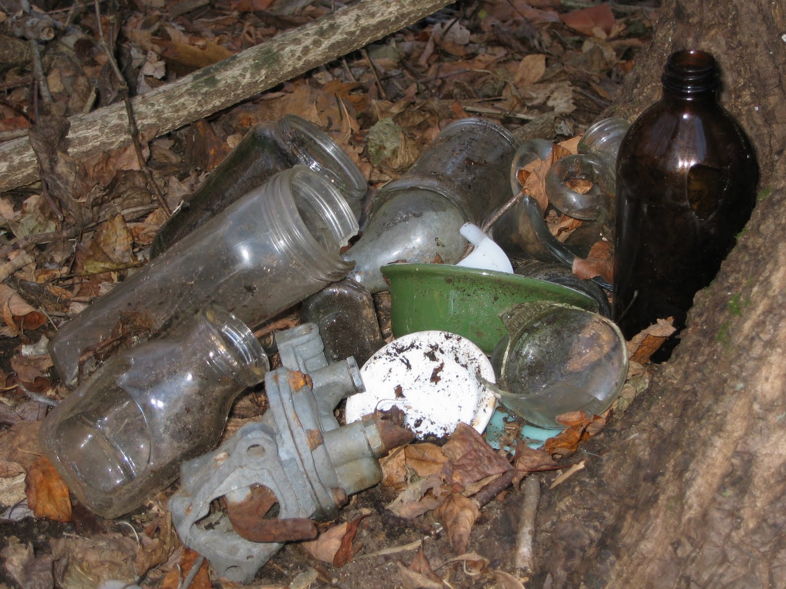 that consisted mostly of, what appears to be, cans (photo 1). There were also broken small milk bottles, pieces of wood, a metal cable, a clay pipe, a metal vent tube, wood, old fenceing and one large glass bottle with a rusted cap still in place and clear liquid inside.
At no point, did I find any labels to indicate what the cans held or what might be swishing around inside the large bottle.
The dump pile was at the top of a ridge so I decided to explore below and found more items (photos 2 and 3), including broken ceramic dishes, a light bulb, shards of what looked to be window glass and a piece that appears to have come from an electric motor. There was also a section of a large corrugated metal pipe.
I did find one small bottle intact and will try to get it dated to get a rough estimate on how long the trash has been there.

For me, this is just more proof that the land went virtually unused for decades and while it appears that it would have been a great hiking spot, few took advantage of the site.
I'm wonder if the trash also indicates that the state and/or CVH did not make sure the site was cleaned up after the farm was closed, or if the land was a haven for illegal dumping once it was no longer used to raise chickens.
Subscribe to:
Posts (Atom)